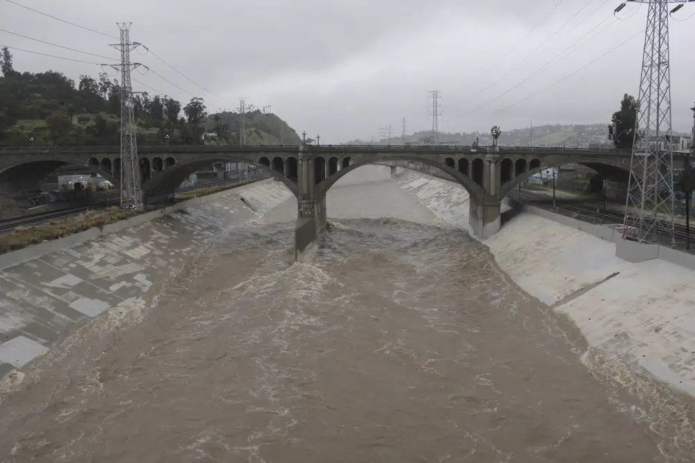
A powerful winter storm that swept down the West Coast with flooding and frigid temperatures shifted its focus to southern California on Saturday, piling up snow and swelling rivers with runoff.
Blizzard warnings continued in the mountains and flood advisories blanketed the region, but forecasters offered some relief, predicting the storm would taper off later in the day.
After days of fierce winds, toppled trees and downed wires, more than 120,000 California utility customers remained without electricity, according to PowerOutage.us. And Interstate 5, the West Coast’s major north-south highway, remained closed due to heavy snow and ice in Tejon Pass through the mountains north of Los Angeles.
Multiday precipitation totals as of Saturday morning included a staggering 81 inches (205 centimeters) of snow at the Mountain High resort in the San Gabriel Mountains northeast of Los Angeles and up to 64 inches (160 centimeters) farther east at Snow Valley in the San Bernardino Mountains.
“There’s already been reports of 2 to 3 feet (60 to 90 centimeters) across some of the higher peaks, and we’re looking at an additional foot, maybe two, of additional snowfall through the rest of the day,” said National Weather Service meteorologist Zach Taylor.
The weather service had warned Friday of possible overnight flash floods, landslides and mudslides in Los Angeles County near creeks, streams, urban areas, highways and areas that were burned by wildfires. The threat zone included downtown L.A., Hollywood, Beverly Hills and many suburbs.
Flash flooding did hit nearby Ventura County early Saturday, where up to 7 inches (18 centimeters) of rain fell, but by 6 a.m. Saturday, the weather service said the heavy rain in both counties had ended and that flooding was no longer a threat.
Meanwhile, people farther east were struggling to deal with the fallout from storms earlier this week.
Almost 400,000 customers were without power in Michigan as of early Saturday afternoon, according to poweroutage.us. The two main utilities in the state, DTE and Consumers Energy, have said they hope to have the lights back on for most of their customers by Sunday night.
Brian Wheeler, a spokesman for Consumers Energy, said half an inch (1.27 centimeters) of ice weighed down some power lines — equivalent to the weight of a baby grand piano.
In Kalamazoo, Michigan, Allison Rinker was using a borrowed generator to keep her 150-year-old house warm Saturday after two nights in the cold and dark.
“We were all surviving, but spirits were low on the second day,” she said. “As soon as the heat came back and we were able to have one or two lights running, it was like a complete flip in attitude.”
After driving to a relative’s home to store food, Rinker, 27, compared the destruction of trees to tornado damage.
“The ice that was falling off the trees as it was melting was hitting our windshield so hard, I was afraid it was going to crack,” she said. “There’s just tree limbs everywhere, half of the trees just falling down. The destruction is insane.”
Back in California, the Weather Prediction Center of the National Weather Service forecast heavy snow over the Cascade Mountains and the Sierra Nevada into the weekend.
The low-pressure system was expected to bring widespread rain and snow in southern Nevada by Saturday afternoon and across northwest Arizona Saturday night and Sunday morning, the National Weather Service office in Las Vegas said.
An avalanche warning was issued for the Sierra Nevada backcountry around Lake Tahoe, which straddles the California-Nevada border. Nearly 2 feet (61 cm) of new snow had fallen by Friday and up to another 5 feet (1.5 meters) was expected when another storm moves in with the potential for gale-force winds and high-intensity flurries Sunday, the weather service said.
In Arizona, the heaviest snow was expected late Saturday through midday Sunday, with up to a foot of new snow possible in Flagstaff, forecasters said.
Weekend snow also was forecast for parts of the upper Midwest to the Northeast, with pockets of freezing rain over some areas of the central Appalachians. The storm was expected to reach the central high Plains by Sunday evening.
Yet the cold weather blasting the North and West avoided the southern states, leading to wild temperatures differences. The high temperature for the U.S. on Friday was 93 degrees Fahrenheit (34 degrees Celsius) at Falcon Lake, Texas, while the low was minus-35 degrees Fahrenheit (1.7 Celsius) near Huntley, Montana.
At least three people have died in the coast-to-coast storms. A Michigan firefighter died Wednesday after coming into contact with a downed power line, while in Rochester, Minnesota, a pedestrian died after being hit by a city-operated snowplow. Authorities in Portland, Oregon, said a person died of hypothermia.
Much of Portland was shut down with icy roads not expected to thaw until Saturday after the city’s second-heaviest snowfall on record this week: nearly 11 inches (28 centimeters).
Tim Varner sat huddled with blankets in a Portland storefront doorway shielding him from some of the wind, ice and snow. Local officials opened six overnight shelters but the 57-year-old, who has been homeless for two decades, said it was too hard to push a shopping cart containing his belongings to reach one.
“It’s impossible,” he said. “The snow gets built up on the wheels of your cart and then you find slippery spots and can’t get no traction. So you’re stuck.”
(AP)


